Beltline District Reuse Plan
Reuse Plan
Client
Fairmont, WV
Location
Fairmont, WV
Years
2022-2023
Project Background
The City of Fairmont received technical assistance from the U.S. Environmental Protection Agency’s (U.S. EPA) Office of Brownfields and Land Revitalization (OBLR) and U.S. EPA Region 3 to prepare a Brownfields Revitalization Plan and Brownfields Health Assessment for the Beltline District of Fairmont, WV.
The Beltline District (the District) was identified by the City of Fairmont, along with key stakeholders, as a high priority area for redevelopment and a Community-Wide Brownfields Assessment was recently completed. Several site-specific assessments were conducted in the study area, as well as an Environmental Summary of brownfield issues throughout the Beltline District, which summarizes all assessment activities that have taken place in the past two decades.
Brownfield sites include the former Fairmont Box Factory, located at 1-48 12th Street Extension; a hillside accessed at 1311 14th Street that was formerly a dumping ground for industrial and construction waste; a vacant lot formerly the location of a facility that was used as a machine shop and glass factory; a vacant industrial building at 102 Beltline Street that was most recently used as Fairmont Supply Company; and several properties on 8th 9th and 10th Streets that were formerly Helmick Corporation properties that were part of a foundry and metal fabrication factory.
Project Summary
The Beltline District Brownfields Revitalization Plan (Revitalization Plan) was completed in the Summer and Fall of 2022 to provide an implementation plan to:
1) Return underutilized and brownfield properties in the Beltline District to productive economic use,
2) Create the infrastructure needed to support property reuse, and
3) Promote public and environmental health.
The Revitalization Plan outlines a strategy for returning the neighborhood’s former industrial properties to a new highest and best use based on current physical and social conditions in the District. With Fairmont Avenue as a north-south artery of commercial properties extending south of Downtown Fairmont, there is a concentration of former industrial properties lining the eastern boundary of the Beltline District along the Monongahela River including a cluster of vacant and/or partially occupied properties in the southeast portion of the study area. The Revitalization Plan proposes a reuse for these vacant and/or partially occupied properties which present the most potential for impactful brownfield reuse. Reusing these brownfield sites will require transportation and infrastructure improvements to provide the utilities, parking, and access that new uses will need. Furthermore, multimodal and vehicular traffic infrastructure adjustments will improve the District’s existing circulation and support the increased traffic to and from proposed infill developments.
The Beltline District Brownfields Revitalization Plan was developed based on:
- A physical neighborhood conditions analysis conducted through a review of available data and previous planning documents as well as several site visits to District Properties
- A synthesis of input provided by key stakeholders and the public during engagements facilitated as part of the planning process
- Findings of a Brownfields Health Assessment that was completed alongside the planning process
Outcomes of the Brownfield Health Assessment (BHA)
A BHA was developed to aid reuse decision-making and developing a revitalization strategy for the Beltline District. EPA contractors conducted the BHA, which used a mixed methods approach and summarizes the potential community health impacts associated with the redevelopment of the Beltline District, based on community health data, scientific literature review, and feedback received from community members.
The BHA did not assess a specific revitalization strategy, program, policy, or decision, as one was not available at the time of the BHA, but rather examined four revitalization elements being proposed for the Beltline District (rail trail, community center, streetscape improvements, and new medical facility) and their associations with public health impacts, beneficial and detrimental, with a particular emphasis on key health behaviors (diet, physical activity, substance use) and outcomes (asthma, cancer, obesity, self-reported health status, mental health, and physical health) for the Beltline District community. Social determinants of health across five domains (economic conditions, education, health care, physical environment, social and community context) were reviewed, as they influence those key outcomes and behaviors. The assessment identified the existing conditions in the study area related to these determinants of health, considered community concerns and desires expressed in the City’s public meetings and interviews conducted as part of the Land Revitalization Technical Assistance Contract, and identified potential impacts and recommendations for the proposed revitalization elements.
Proposed revitalization options for the Beltline District have the potential for promoting health, particularly if considering the recommendations provided for each option, for example, by increasing employment opportunities for the District and surrounding areas, improving health and environmental literacy, strengthening before- and after-school educational programs, enhancing job training and skills development opportunities, providing resources for physical activity and active living, creating volunteering opportunities, improving access to healthcare, and reinforcing social cohesion. Of note, revitalization options need to be planned and developed in such a way as not to displace or otherwise adversely impact current residents.
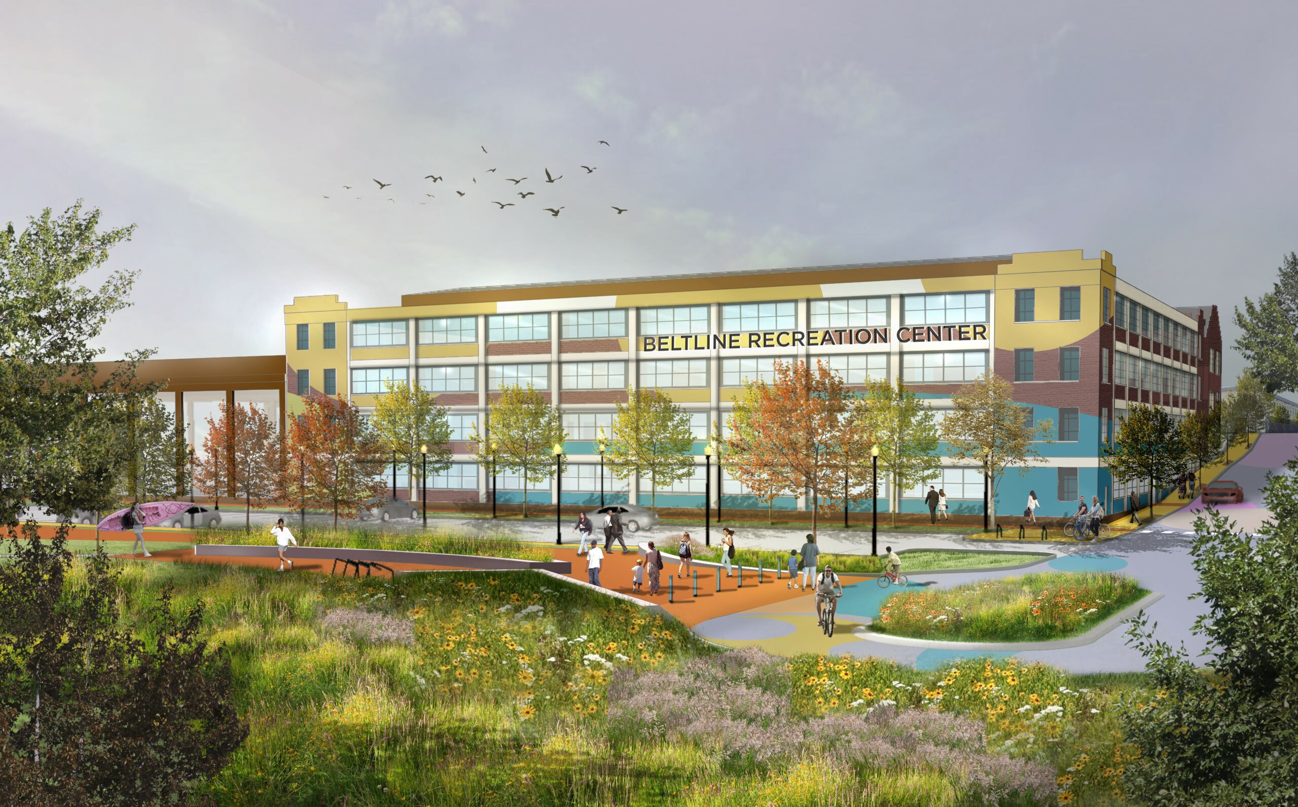
Revitalization Plan
The Revitalization Plan focuses on the vacant brownfield sites and streetscapes on and surrounding 10th and 12th Streets as a primary focus for community and brownfield revitalization. The Revitalization Plan proposes new developments on 10th and 12th Streets including:
a Medical Clinic,
a Community & Recreation Center,
a Trailhead,
an Industrial Cluster,
a Rehabilitation Center, and
an Out-patient Rehabilitation Facility on 10th and 12th Streets.
The Revitalization Plan also proposes traffic and streetscape improvements throughout the study area including: unidirectional traffic and streetscape improvements on Gaston and Virginia Avenues, as well as streetscape and parking improvements surrounding the new developments.
Implementing the Beltline District Brownfields Area-Wide Revitalization Plan will transform the District into a mixed-use neighborhood that is thriving with residential and recreational spaces that make the District an attractive place to live alongside new and legacy commercial and industrial spaces that support the local workforce and economy.
Rehabilitation Facilities
The Rehabilitation Facility is proposed to be located on a secluded campus site, overlooking the Monongahela River with 60 beds in an approximately 60,000 square foot facility. The placement affords the ability to deemphasize its primary patient entrance via 9th Street, with a separate entrance via 10th Street to be utilized by staff and service personnel, providing a significant separation between the rehabilitation facility’s front door and the nearby Fairmont West Middle School. The proposed Rehabilitation Facility will meet a critical need in the community by offering much needed 24-hour care programs for community members suffering from substance addictions and mental health issues.
The Helmick Administrative Building, should the opportunity for reuse arise, is proposed for adaptive reuse as an Outpatient Medical Clinic to provide outpatient programs that complement programs offered at the adjacent Medical Facility.
Services
Urban Design
Brownfields Reuse Planning
Parks, Recreation, & Green Space
Resiliency, Green Infrastructure, & Landscape Utilities