The U.S. EPA’s Area‐Wide planning component of its overall brownfields grant program is the best tool available for communities striving to ensure that as their specific brownfields are remediated and redeveloped, the activities are done in a manner that closely aligns with its community’s vision, goals, and for maximum community benefit.
Planning informs decision-making and decision-makers. Understanding not only what type of use(s) will ultimately occur on a site, but ideally, how the use(s) will actually be configured on the ground can greatly influence all aspects of on‐site characterization activities, such as the number of samples required and their ideal locations. Furthermore, knowing the intended end use can aid in deciding which approach to obtaining a certificate of completion under voluntary clean‐up programs is best, including if a site‐specific standard approach will be the most practical.
Equipped with information about both the existing environmental conditions and the intended end use and site development layout, opportunities to link end use elements that specifically consist of elements conducive of impervious cover, such as parking lots and hardscaped areas, may be able to be incorporated into site engineering controls to also function as impervious “caps” over areas requiring this type of remedial action. The only way to have sufficient information to know how potential remedial actions will relate and to potentially capture “added value” through an integrated approach, is to also know what the desired layout will be at the time that remedial actions are being development. In contrast, if site reuse planning is not performed before or in tandem with assessment, resultant remedial strategies may lock down options for site layout which could limit a site’s optimum or even viable reuse.
Planning identifies opportunities for efficiencies in the remedial review and approval process. Beyond the preparation of the remedial strategies, knowing a site’s end use and specific layout aids any regulatory agency reviewer in their process of determine the acceptability of the remedial measure/approach. Without this level of specificity, a reviewer can only assume a future generic condition and apply a categorical regulatory standard. This can potentially result in an unnecessarily conservative conclusion to what is required or a site‐wide application of a remedial action, or even an unnecessary imposition of a land use convent, when they may not be required. Planning provides a level of clarity for the finish line that typically cannot be achieved in its absence.
Evaluating the options for what is possible on a site increases the support and interest in end goals. Without a clear vision for what the future use will be for a site, it is dramatically more difficult to get people excited for the potential that exists. This interest is not limited to developers and the general public, it also aids in aligning all of the involved agencies typically involved in a voluntary clean‐up process, including environmental agencies, but also other permitting entities focused on stormwater, transportation, financing, etc..
Planning processes, especially on larger sites, can determine interim uses that activate sites for productive use much sooner. This is a mechanism that is becoming more and more important in community‐led brownfields redevelopment projects. The general public is yearning for tangible results beyond more sampling data, renderings, and promises. They want to see physical improvement on the ground and in their neighborhoods. Planning can identify smaller and strategic projects which do not require site‐wide actions and millions of dollars to achieve. In most cases, these opportunities cannot be identified without the planning required to identify viable options for quick and tactical successes and build public and agency support for such recommendations.
Understanding the traditional requirements regulating land development can inform decisions on the level of assessment required and approaches to remediation. Only through an analysis that is required for any land development project, i.e., determining setbacks, land coverage requirements and ratios, floor area ratios, etc. can the potential development yield of site be determined. This is critical since sites may be treated from an environmental perspective as if they will be used for an intended end use, when in fact there is no buy‐right way to accommodate such a use.
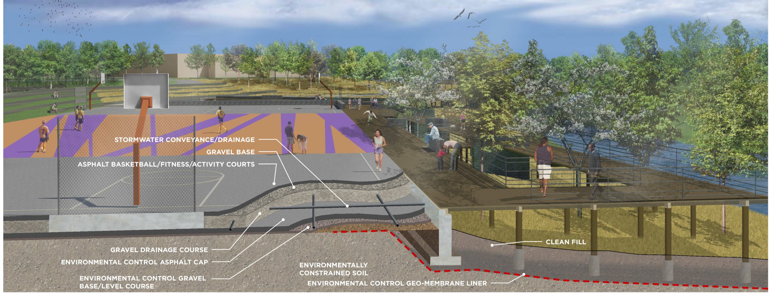
Infrastructure needs for future development should be considered during the assessment step. These considerations include the locations of future underground utilities, stormwater management facilities, and potential resiliency aspects such as required topographic regarding for flood resiliency, etc. In many cases, the first thing constructed will set the stage for everything that will follow; good or bad.
The U.S. EPA Brownfields grant program provides a mechanism to undertake several significant planning aspects that can greatly improve the success of any community’s
brownfields endeavors. Planning is the glue that holds everything together, both in terms of each of the projects, but ultimately ensuring that a successful community is created from the bones of the brownfields from which they started.